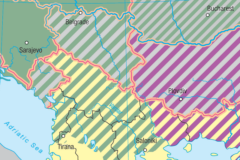
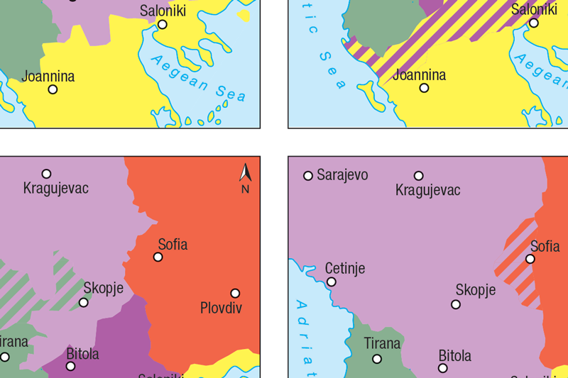
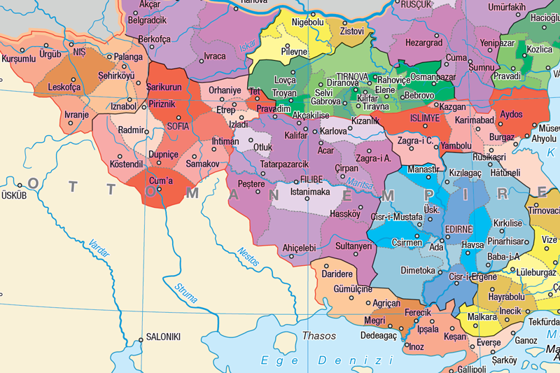
Map 1
A part of Müller’s sketch map from the 1840s
Source
Müller, Joseph: Albanien, Rumelien und die österreichisch-montenegrische Grenze. Prague, 1844.
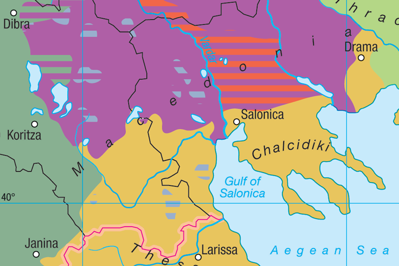
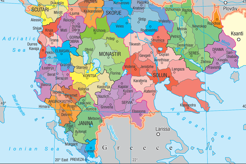
Map 2
Parts from the sketch-map of Hahn in the 1860s
Source
Hahn and Zach: The Bulgarians in Southwest Moravia, 1861 (illumined by Teodoroff-Balan. The Balkan Question Library, Sofia, 1917)
Map 4
The plan of Calice from 1896
Source
Demeter, Gábor: “Expansionism or Self-Defence? The Plans of Austro-Hungarian Diplomatic Circles against Serbia (1913–1915)”. In: Bulgaria and Hungary in the First World War: A View from the 21st Century
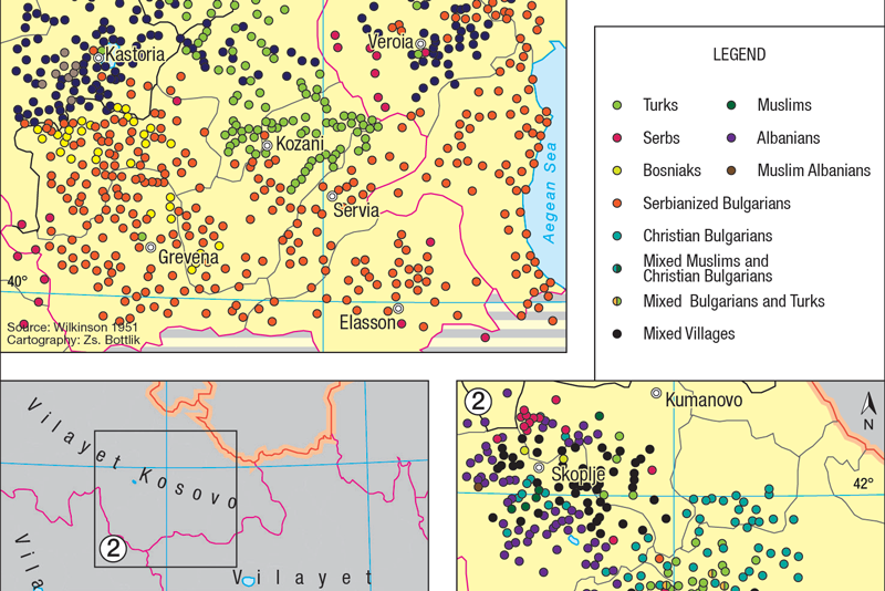
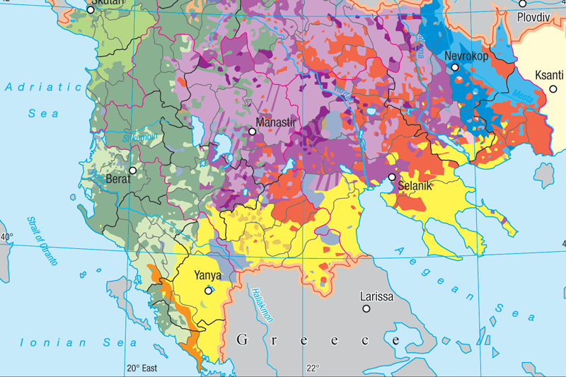
Map 5
Ethnographic distribution of population in Macedonia
Source
Brailsford, H. N.: Macedonia. Its Races and Future. London, Methuen, 1906
Map 6
A simplified ethnic map of the Balkans for Hungarian military officers
Source
Magyar Katonai Közlöny (Hungarian Military Bulletin), 1913, April
Map 8
A simplified sketch map of the evolution of Cvijić’s ideas
Source
White, George, B.: Nationalism and Territory: Constructing Group Identity in Southeastern Europe. 2000.
Map 9
The ethnic map of Chekrezi (N. Lako) on the southern border of Albania in 1913
Source
Chekrezi, C.: Albania. Past and Present. New York, Macmillan, 1919
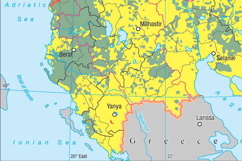
Map 10-11
Schultze-Jena’s map from the last years of Ottoman rule, published in 1927
Hasluck’s map from 1930, showing ethnic diversity in Macedonia in 1923
Sources
Wilkinson, Henry, R.: Maps and Politics. A Review of the Ethnographic Cartography of Macedonia. Liverpool Univ. Press, 1951, 251.
Wilkinson, Maps and Politics, 253.
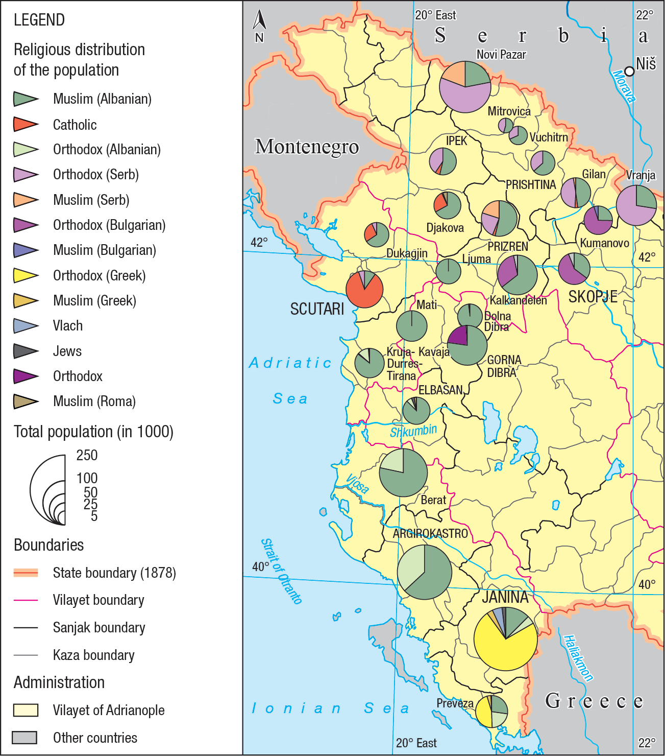
Map 12
Ethnic/Religious map of European Turkey based on the census of 1906
Source
Fodor, Pál: Kisebbségek az Oszmán Birodalomban (Minorities in the Ottoman empire), 14-20. sz. História 34 (2012/8) 30-34.
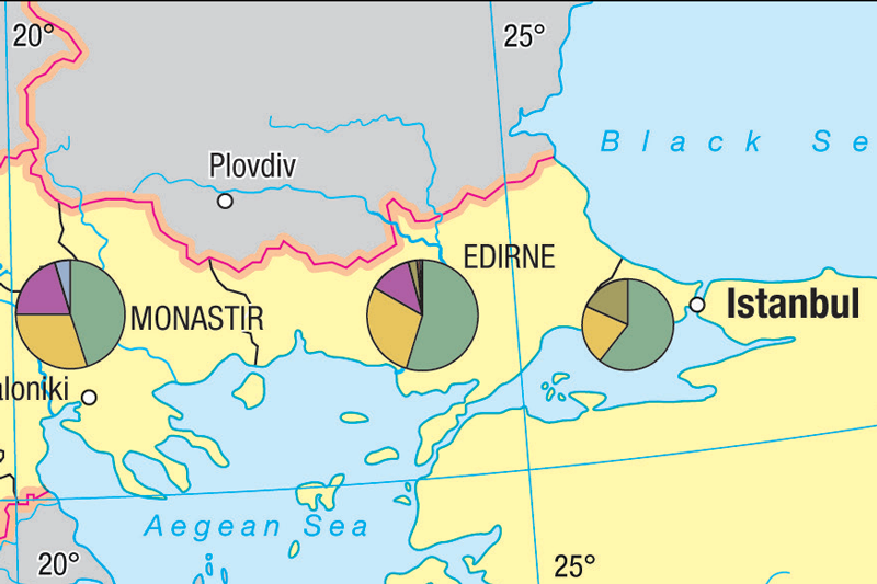
Map 13a
Kaza-level administrative map of Tuna and Edirne Vilayets after 1878
Source
Kornrumpf, Hans-Jürgen: Die Territoralverwaltung im östlichen Teil der europäischen Türkei vom Berliner Kongress (1878) bis zu den Balkankriegen (1912/13) nach amtlichen osmanischen Veröffentlichungen. Rudolf Trofenik, München, 1983.
Kornrumpf, H-J.: Die Territoralverwaltung im östlichen Teil der europäischen Türkei vom Erlass der Vilayetsordnung (1864) bis zum Berliner Kongress (1878) nach amtlichen osmanischen Veröffentlichungen. Freiburg, Klaus Schwarz Verlag, 1976.
Map 13b
Kaza-level administrative map of Macedonian vilayets after 1900
Source
Kornrumpf, Hans-Jürgen: Die Territoralverwaltung im östlichen Teil der europäischen Türkei vom Berliner Kongress (1878) bis zu den Balkankriegen (1912/13) nach amtlichen osmanischen Veröffentlichungen. Rudolf Trofenik, München, 1983.
Kornrumpf, H-J.: Die Territoralverwaltung im östlichen Teil der europäischen Türkei vom Erlass der Vilayetsordnung (1864) bis zum Berliner Kongress (1878) nach amtlichen osmanischen Veröffentlichungen. Freiburg, Klaus Schwarz Verlag, 1976.
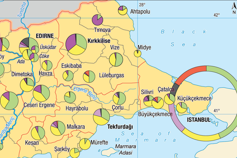
Map 14a
Kaza-level ethnographic map of Tuna and Edirne Vilayets after 1831
Source
https://www.wikizero.com/en/Demographics_of_the_Ottoman_Empire
Map 14b
Kaza-level ethnographic map of Macedonian vilayets after 1831
Source
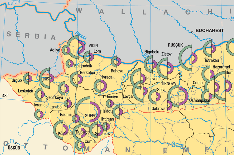
https://www.wikizero.com/en/Demographics_of_the_Ottoman_Empire
Map 15
Ethnic map of Macedonia prior to 1878 (Extrait)
Source
Etnographie des vilayets d'Adrinople, de Monastir et de Salonique. Constantinople, 1878. Extrait du Courier d'Orient.
Map 16
Ethnographic map of North-Macedonia (Kosovo Vilayet) before 1878 (Austrian version)
Source
Frantz, Anne, Eva: Gewalt und Koexistenz. Muslime und Christen im spätosmanischen Kosovo (1870-1913). München: De Gruyter-Oldenbourg, 2016. (based on original sources of the HHStA)
Map 17
Ethnic map of South-Macedonia prior to 1878 (English version)
Source
Turkey, No. 15. Correspondence respecting the New Law for the European Provinces of Turkey. Presented to both Houses of Parliament by Command of Her Majesty. London, 1880. Lord E. Fitzmaurice to Earl Granville, Büyükdere, June 12, 1880. Part I. IV-161.
Map 18
Ethnic map of South-Macedonia in 1902 (Ottoman version)
Source
Şaşmaz, Musa: Analysis of the Population Table of the Census of Salonica of 1903-4. OTAM, dergiler.ankara.edu.tr/dergiler/19/1151/13523.pdf and the Turkish yearbook of 1902 for the Bitola Vilaet
Map 19
Ethnic map of Macedonia prior to 1878 (based on the Ottoman census)
Source
Ivanov, Yordan: Balgarite v Makedoniya. Izdirvaniya i dokumenti, za tyahnoto poteklo, ezik i narodnost s etnografska karta i statistika. Sofia, darzhavna pechatnitsa, 1915. 165.

Map 20
Ethnic map of Macedonia in 1881 (based on the Ottoman census)
Source
Ivanov, Balgarite v Makedonija, 166
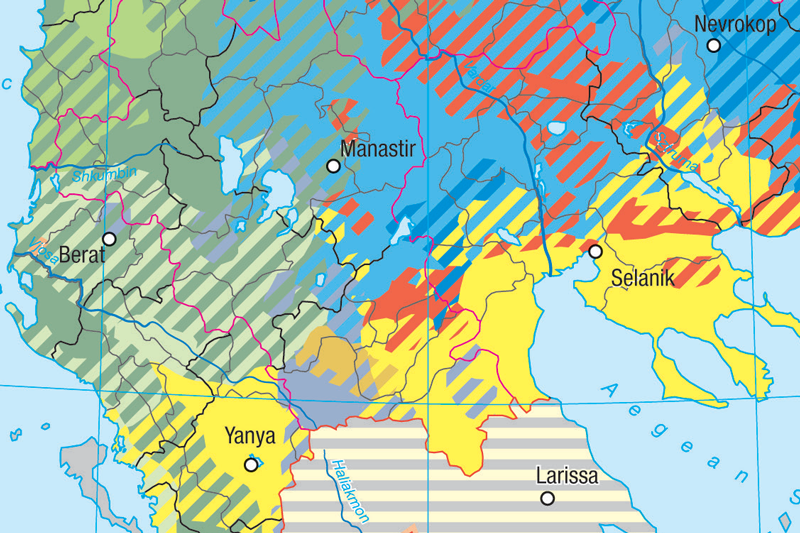
Map 22
Ethnographic patch map of Macedonia, cca. 1900 (Austrian version)
Source
HHStA, PA XII, Türkei, Liasse XXV, Kt. 272.
Map 23
Religious patch map of Macedonia, cca. 1900 (Austrian version)
Source
HHStA, Kartensammlung, Keller 3. 7-3.
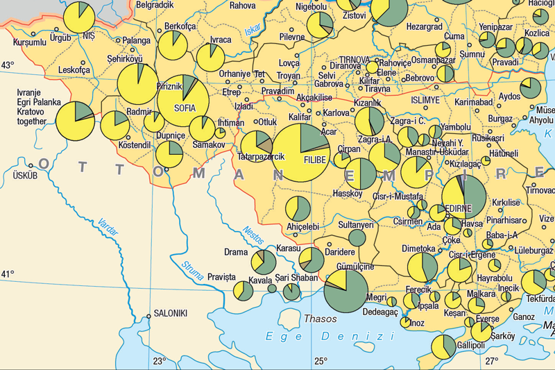
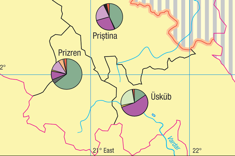
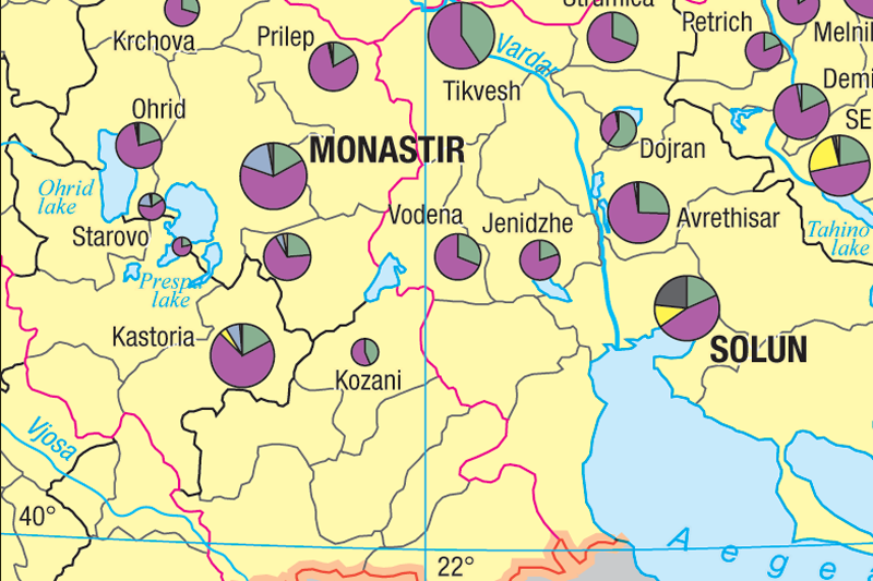
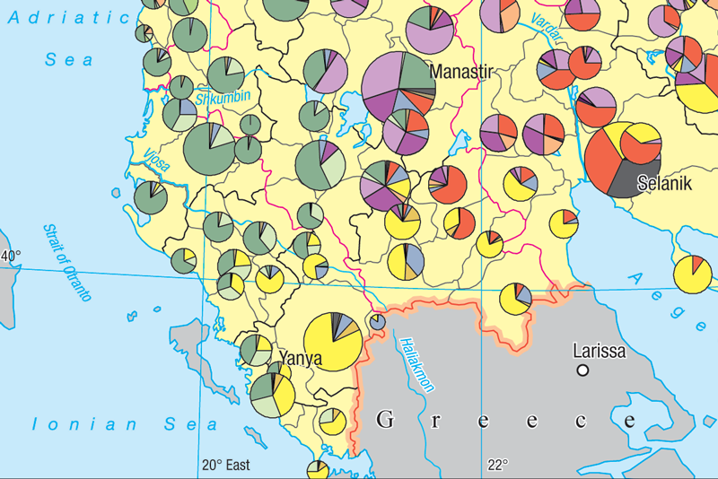
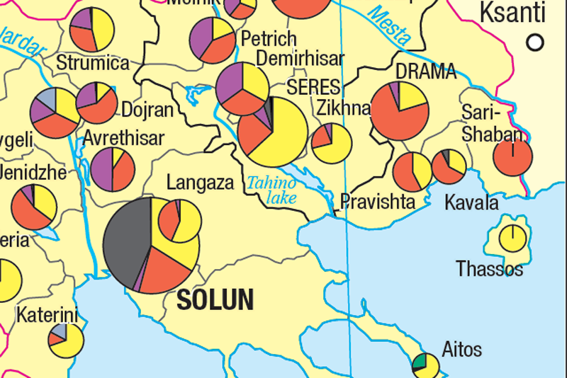
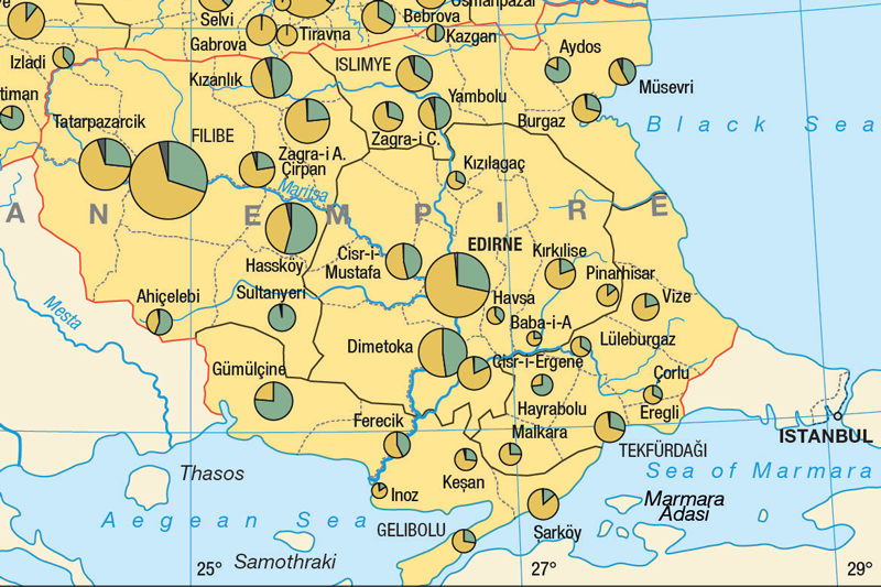
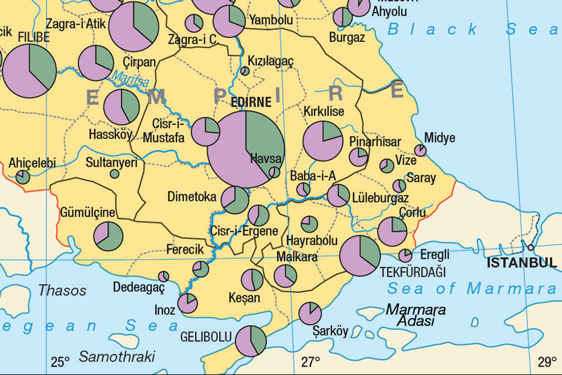
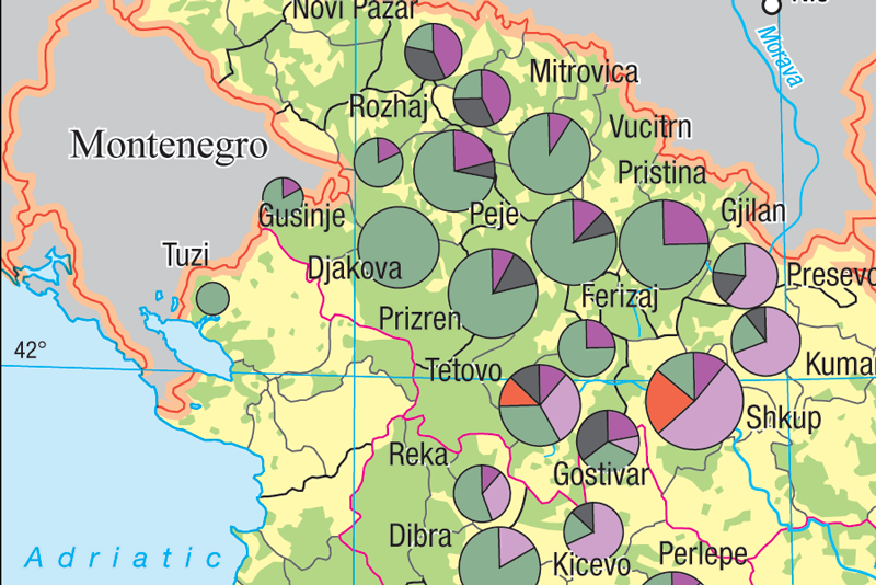
Map 24
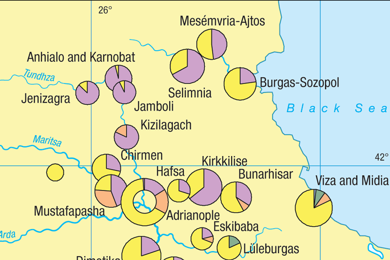
Kaza-level religious pie chart map map of Macedonia cca. 1900 (Austrian version)
Source
HHStA, PA XII, Türkei, Liasse XXV, Kt. 272-274.
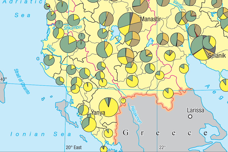
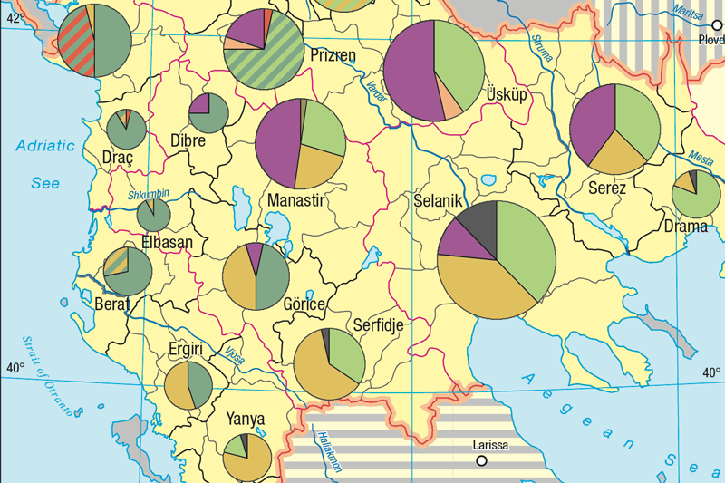
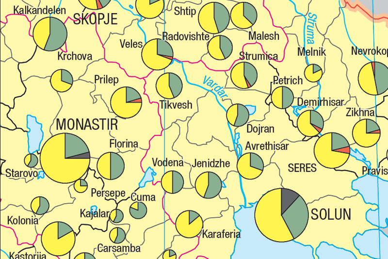
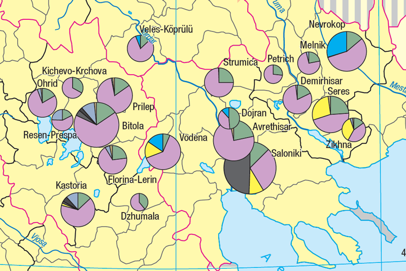
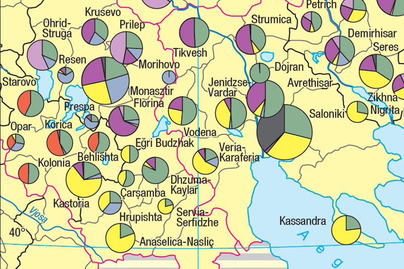
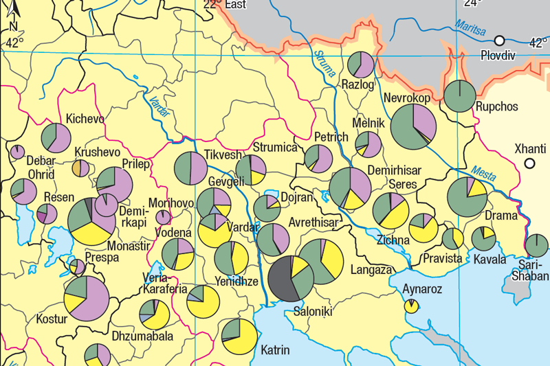
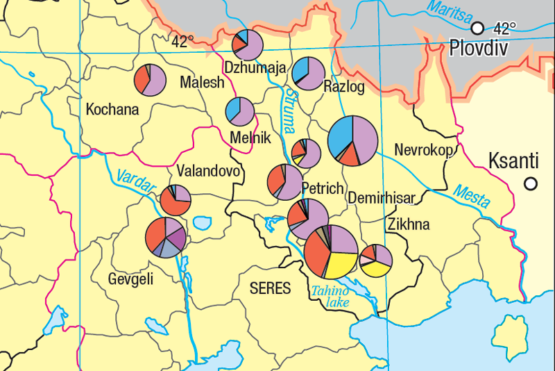
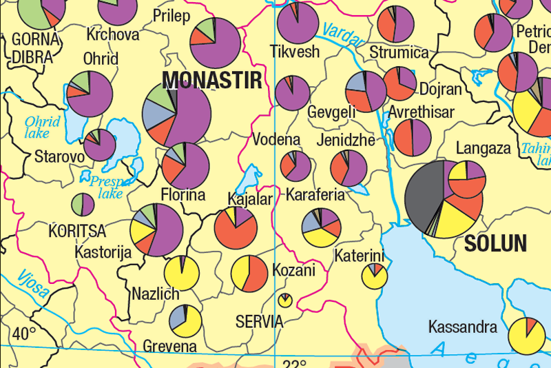
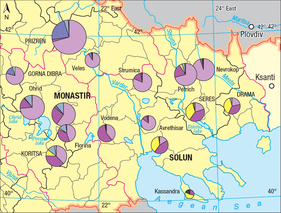
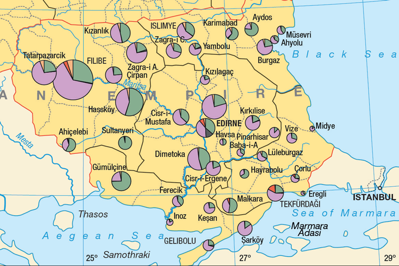
Map 25
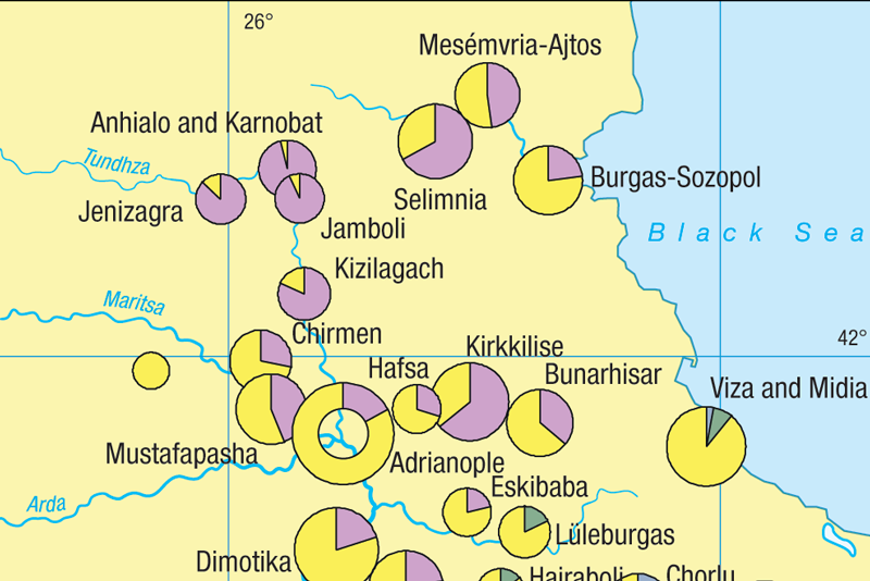
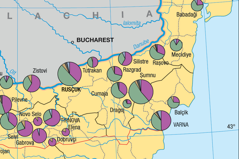
Kaza-level ethnic pie chart map of Macedonia, cca. 1900 (Austrian version)
Source
HHStA, PA XII, Türkei, Liasse XXV, Kt. 272-274.
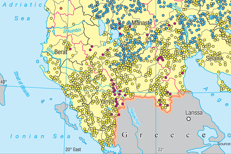
Map 26
Christian schools in Macedonia, cca. 1900
Source
HHStA, PA XII, Türkei, Liasse XXV, Kt. 272.
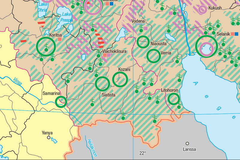
Map 27
Churches and schools in Macedonia, cca. 1900 (based on Phocas-Cosmetatos)
Source
HHStA, PA XII, Türkei, Liasse XXV, Kt. 273.
Map 28
Ethnographic distribution of the population in Saloniki Vilayet (Gopčević, 1889)
Source
Ivanov, Balgarite v Makedonija, and Gopčević. Makedonien und Alt-Serbien, 1889.

Map 29
Ethno-religious distribution of the population in Macedonia (based on Kănchov's trip in 1894)
Source>
Kanchov, Vasil: Makedoniya. Patopisi. Sofia, Akademichno Izdatelstvo Marin Drinov, 2000
Map 30
Ethnographic distribution of the population in Macedonia according to Nikolaides (1899)
Source
Ivanov, Balgarite v Makedoniya
Map 31
Ethnographic distribution of the population in Macedonia according to Ivanov (1912)
Source
Ivanov, Balgarite v Makedoniya
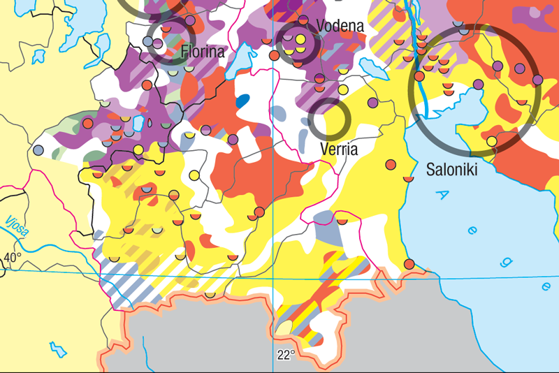
Map 32
Majority patch map of Macedonia from 1905 (Austrian)
Source
HHStA PA XII Türkei Liasse XXV, Kt. 272. 1896-1902
Map 33
Ethnic distribution of the Christian population according to R. von Mach (1906)
Source
Ivanov, Balgarite v Makedoniya
Map 34
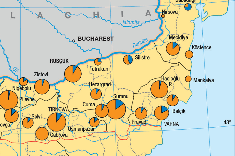
Religious distribution of the population in Tuna and Edirne Vilayets, cca. 1873
Source
Kornrumpf, H-J.: Die Territoralverwaltung im östlichen Teil der europäischen Türkei vom Erlass der Vilayetsordnung (1864) bis zum Berliner Kongress (1878) nach amtlichen osmanischen Veröffentlichungen. Freiburg, Klaus Schwarz Verlag, 1976
Map 35
Ethnic distribution of the population in Edirne Vilayet, cca. 1873
Source
Kornrumpf, H-J.: Die Territoralverwaltung and Salnâme-i Vilâyet-i Tuna, Defa 6, Sene 1290, 106-309 (cited by Koyuncu, table 12, 702).
Map 36
Ethno-religious distribution of the urban population in Tuna and Edirne Vilayets, cca. 1874
Source
Kornrumpf, H-J.: Die Territoralverwaltung
Map 37
Religious distribution of the Christian population in Macedonia and Thrace (Syllogos and the Greek Patriarchate, 1878)
Source
Turkey, No. 31. Correspondence respecting the Objections raised by Populations inhabiting Turkish Provinces against the territorial changes proposed in the Preliminary Treaty signed at San Stefano. Presented to both Houses of Parliament by Command of Her Majesty. 1878, London, Harrison and sons. 16-38. Memorandum des Syllogues Grecs de Constantinople. Jean D. Aristocles, 6 Avril, 1878. M.A.H. Layard, Ambassadeur de Sa Majesté
Map 38
Language distribution of the Christian population in Macedonia and Thrace II. (Syllogos and the Greek Patriarchate, 1878)
Source
Turkey, No. 31. Correspondence respecting the Objections ... Memorandum des Syllogues Grecs de Constantinople…
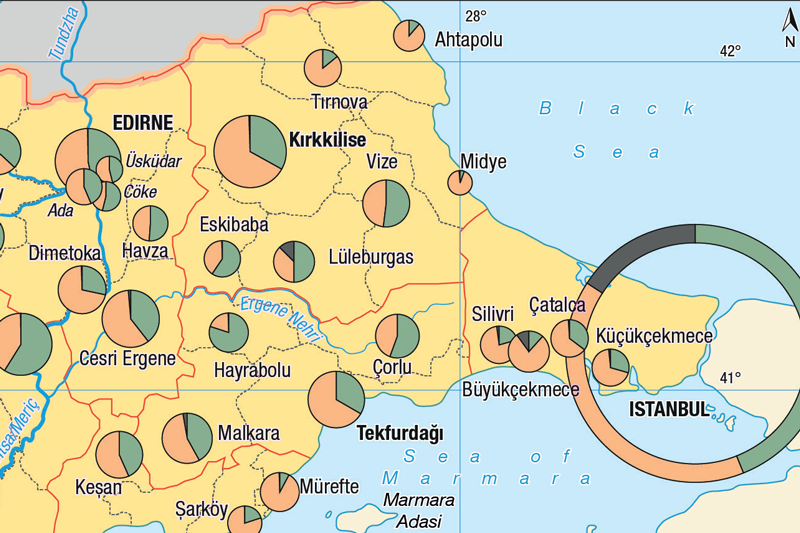
Map 39
Ethnic distribution of the urban population in Tuna Vilayet before 1878
Source
Pándi, L.: Köztes-Európa Atlasz. Bp. Osiris, 1996. Data from Aubaret.
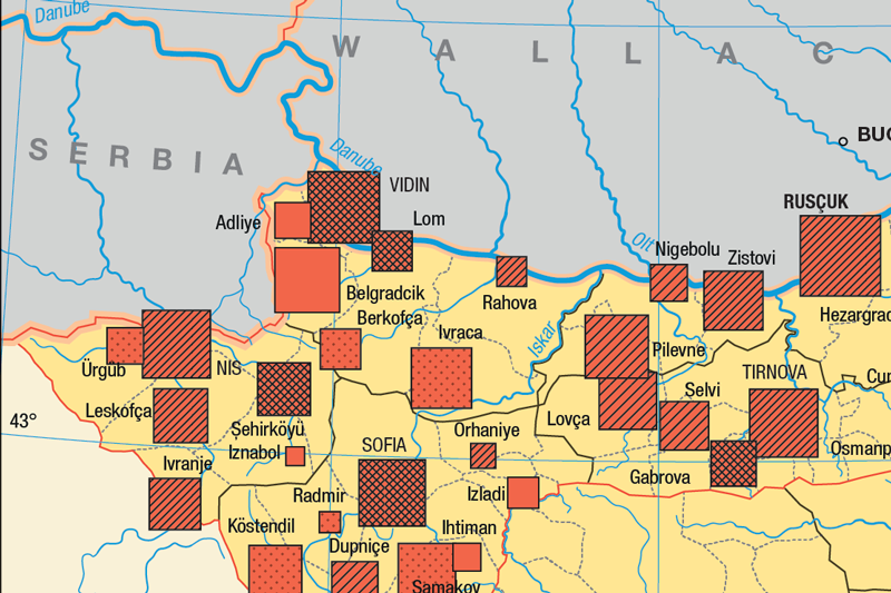
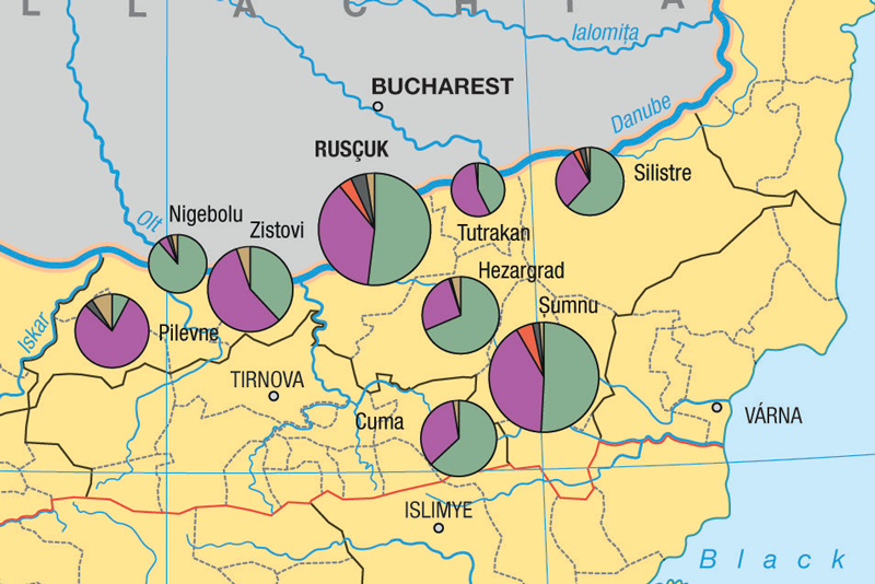
Map 40
Significance and central function of towns in Tuna Vilayet, 1876
Source
Kornrumpf, H-J.: Die Territoralverwaltung
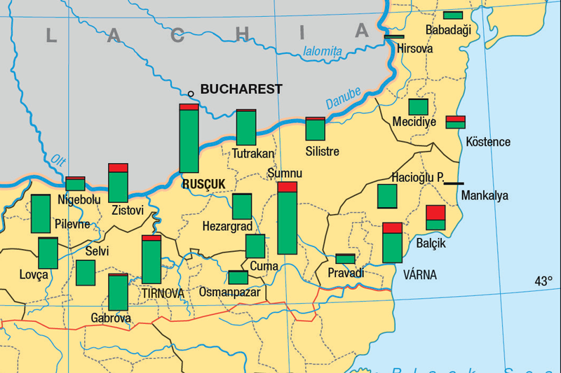
Map 41
Churches and mosques in the towns of Tuna Vilayet, 1876
Source
Kornrumpf, H-J.: Die Territoralverwaltung
Map 42
Inns (han) and baths (hamam) in the towns of Tuna Vilayet, 1876
Source
Kornrumpf, H-J.: Die Territoralverwaltung
Map 43
Stores and bazaar shops in the towns of Tuna Vilayet, 1876
Source
Kornrumpf, H-J.: Die Territoralverwaltung
Map 44
Religious distribution of the population in Edirne Vilayet, cca. 1881
Source
Kornrumpf, H-J.: Die Territoralverwaltung (1983)
Map 45
Ethnic distribution of the population in Edirne Vilayet, cca. 1881
Source
Kornrumpf, H-J.: Die Territoralverwaltung (1983)
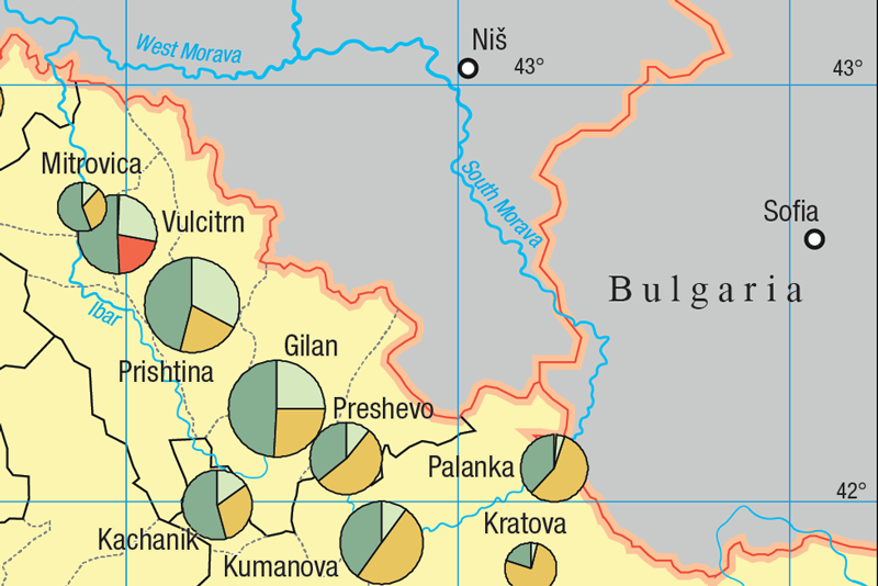
Map 46
Ethnic distribution of the population in Kosovo Vilayet and the proportion of muhadjirs, cca. 1881
Source
BOA, Y. PRK. UM, 1/99. Osmanli Arsiv belgelerinde. Kosova Vilayeti. T.C. Basbakanlik. Devlet ArsivleriGenel Müdürlügü, Istambul, 2007, 332-334.
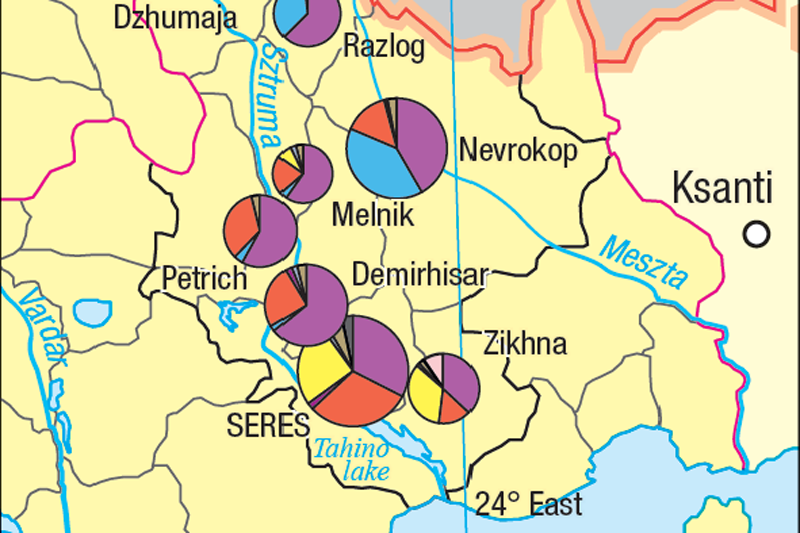
Map 47
Ethnic distribution of the population in Seres Sanjak, cca. 1881 (Hondros)
Source
Hondros, C.: Brevi cenni sui circondario di Serres del sig. Cost. Hondros Reggente la R. Agenzia Consolare in Serres, communicati dal Cav. F. Zerboni R. Console a Salonicco. 1881. és Bollettino Consolare pubblicato per cura del Ministero per gli Afferi Esteri di S. M. il Re d'Italia. Vol. XVII. Parte II. Roma 1881. 729-742.

Map 48
Ethnic distribution of the population in Seres Sanjak, cca. 1894 (Kănchov)
Source
Kanchov, Makedoniya. Patopisi.
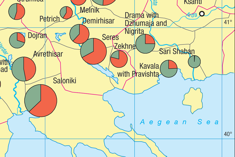
Map 49
Religious distribution of the population in Saloniki Vilayet in 1880
Source
Turkey, No. 15. Correspondence respecting the New Law for the European Provinces of Turkey. Presented to both Houses of Parliament by Command of Her Majesty.London, 1880. Lord E. Fitzmaurice to Earl Granville, Büyükdere, June 12, 1880 Part II. 161-292.
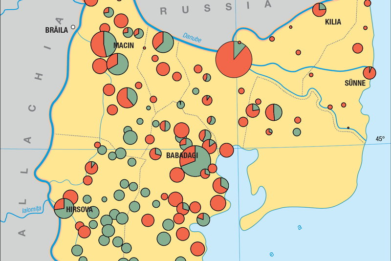
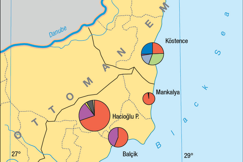
Map 50
Ethnic distribution of the population in Dobrudja before 1878
Source
Kornrumpf, H-J.: Beitraege zur Osmanische Geschichte und Territorialverwaltung. Analecta Isisiana. Isis press, Istanbul, 2001 (Zur Verwaltungsgliederung der Dobrudscha in den letzten Jahren der Osmanischen Herrschaft (351-366).
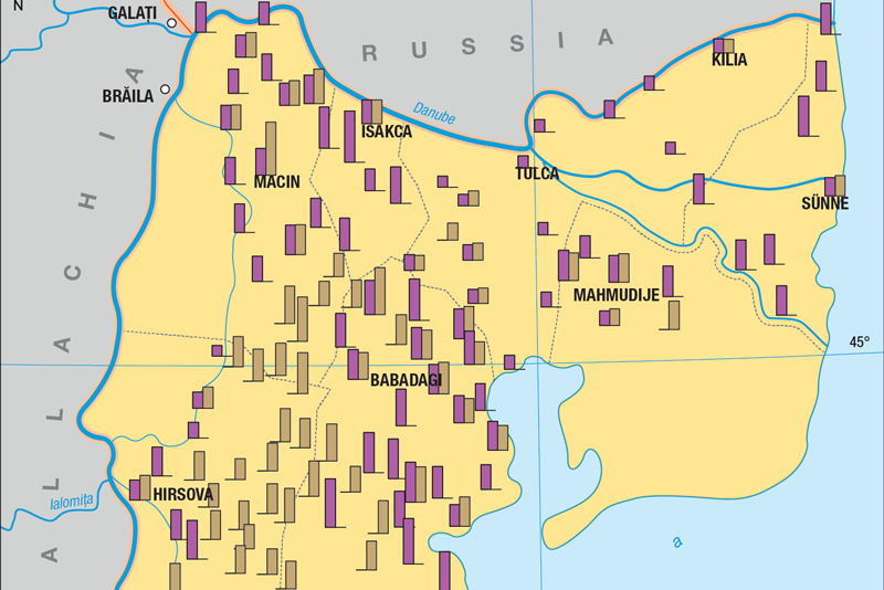
Map 51
Average family size for Muslim and Christian population in Dobrudja before 1878
Source
Kornrumpf, H-J.: Beitraege zur Osmanische Geschichte und Territorialverwaltung. Analecta Isisiana. Isis press, istanbul (Zur Verwaltungsgliederung der Dobrudscha in den letzten Jahren der Osmanischen Herrschaft (351-366).
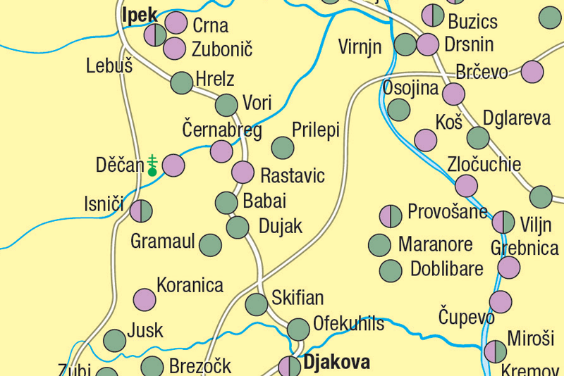
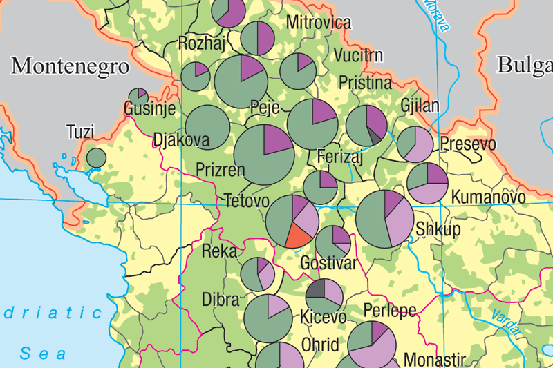
Map 52
Settlement-level ethnic map of southern Macedonia (Ivanov, cca. 1910)
Source
HHStA, Kartensammlung, Keller 3. 7_9.
Map 53
Religious distribution of the population in Dobrudja and the Danubian vilayet according to Moshnin (Russian, 1877)
Source
Moshnin, A. N.: Pri-Dunayskaya Bolgariya (Dunayskiy vilayet). Statistiko-ekonomicheskiy ocherk. Sankt Peterburg, 1877. 346-404.
Map 54
Ethnic distribution of the population in Dobrudja according to Ionesco (Romanian, 1852)
Source
Ionesco, I.: Excursion agricole dans la plaine de la Dobrodja. Constantinople, 1850.
Map 55
Ethnic distribution of the urban population in Northern Bulgaria (Russian, 1877)
Source
Obruchev, N. N.: Voenno-statisticheski sbornik na 1868 god. Vipusk II. 1868, Tom III. 349.p.
Map 56
Sketch map on the ethnic distribution of the population in Albania (cca. 1912)
Source
HHStA PA XII Türkei Liasse XXV, Kt. 273.
Map 57
The boundaries and ethnic contact zone of the Albanian nation (Ottoman version, 1908)
Source
Kruja, Mustafa, M.: Ne historine Shqiptare. OMSCA-1, Tirana, 2012.

Map 58
The boundaries and ethnic contact zone of the Albanian nation (Austria-Hungary, 1917)
Source
Kruja, Ne historine Shqiptare
Map 59
The boundaries and ethnic contact zone of the Albanian nation (Bulgarian version, 1918)
Source
Kruja, Ne historine Shqiptare
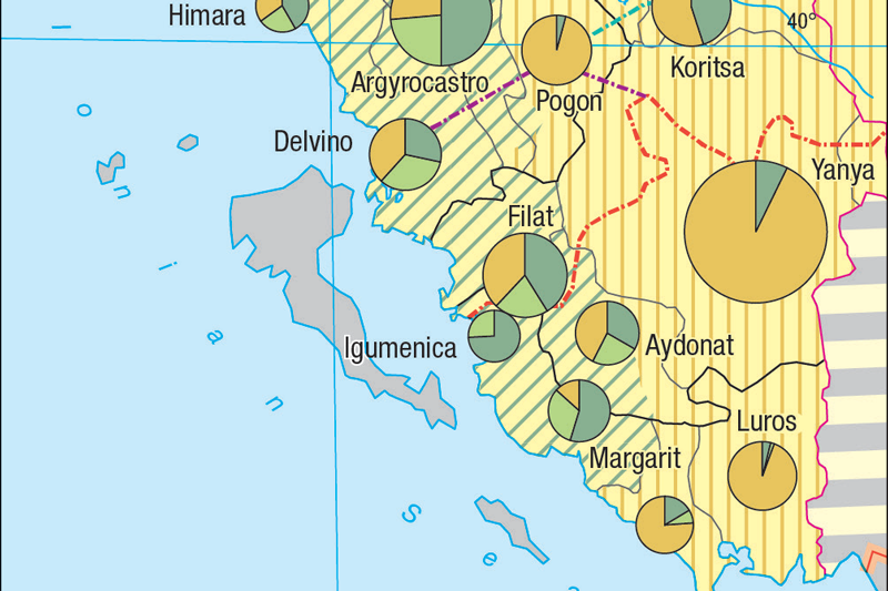
Map 60 Ethnographic data on Albania and the sanjak of Novipazar according to Roukis (1884)
Source
Roukis, Aristides. Ethnographische und Statistische Mitteilungen über Albanien. PGM, 30. 1884. 367-371. https://zs.thulb.uni-jena.de/receive/jportal_jpvolume_00146650
Map 61
Ethnic map of the Balkans in 1910 (based on Ottoman salname)
Source
McCarthy, Justin: Population History of the Middle East and the Balkans. Istanbul, Isis Press, 2002.